By understanding the academic needs we have prepared the Tamilnadu State Board Class 10 Social Science Geography Solutions Chapter Wise. Samacheer Kalvi 10th Social Science Geography Solutions Chapter 6 Physical Geography of Tamil Nadue Questions and Answer. There are 4 parts in Social Science we have provided the topics according to the parts. You can Download Samacheer Kalvi 10th Social Science Book Solutions Guide Pdf, Tamilnadu State Board help you to revise the complete Syllabus and score more marks in your examinations. Before you start your preparation go through the chapters covered in this academic. Our aim is to help the students by providing the question and answers chapter wise and help them to gain a good score in the exams.
Tamilnadu Samacheer Kalvi 10th Social Science Geography Solutions Chapter 6 Physical Geography of Tamil Nadu
The topics covered in Samacheer Kalvi State Board Class 10 Social Science Geography Solutions Chapter 6 Physical Geography of Tamil Nadue are Forest, Wild life, Soil and Water. The solutions provided in Samacheer Kalvi Class 10 Social Science Geography Solutions Chapter 6 Physical Geography of Tamil Nadue Questions and Answer are made by the subject experts. The Samacheer Kalvi Class 10 Social Science Geography Solutions Chapter 6 Physical Geography of Tamil Nadue are prepared according to the latest edition. So go through them and Download Tamilnadu State Board Solutions for Class 10 Social Science Geography Chapter 6 Physical Geography of Tamil Nadue Pdf for free.
Physical Geography of Tamil Nadu Textual Exercise
I. Choose the correct answer.
Physical Geography Of Tamil Nadu Question 1.
The latitudinal extent of Tamil Nadu is …………..
(a) 8°4’N to 13°35’N
(b) 8°5’S to 13°35’S
(c) 8°0′ to 13°5’N
(d) 8°0’S to 13°05’S
Answer:
(a) 8°4’N to 13°35’N
State The Boundaries Of Tamil Nadu Class 10 Question 2.
The longitudinal extent of Tamil Nadu is
(a) 76° 18’E to 80°20’E
(b) 76° 18’W to 80°20’W
(c) 86°18’E to 10°20’E
(d) 86°18’W to 10°20’W
Answer:
(a) 76° 18’E to 80°20’E
10th Geography In Tamil Question 3.
The highest peak in Tamil Nadu is ……………..
(a) Anaimudi
(b) Doddabetta
(c) Mahendragiri
(d) Servarayan
Answer:
(b) Doddabetta
Physical Geography Of Tamil Nadu Book Back Answers Question 4.
Which of the following passes is not located in the Western Ghats of Tamil Nadu?
(a) Palghat
(b) Shencottah
(c) Bhorghat
(d) Achankoil
Answer:
(c) Bhorghat
10th Social Distinguish Between Question 5.
Which one of the following river flows into the Arabian Sea?
(a) Periyar
(b) Cauvery
(c) Chittar
(d) Bhavani
Answer:
(a) Periyar
Question 6.
The district with largest mangrove forest cover in Tamil Nadu is:
(a) Ramanathapuram
(b) Nagapattinam
(c) Cuddalore
(d) Theni
Answer:
(c) Cuddalore
Question 7.
The forest cover of Tamil Nadu as per 2017 Indian Forest Report is ………………
(a) 20.21%
(b) 20.31%
(c) 21.20%
(d) 21.30%
Answer:
(a) 20.21%
Question 8.
Retreating monsoon wind picks up moisture from:
(a) Arabian sea
(b) Bay of Bengal
(c) Indian Ocean
(d) Timor sea
Answer:
(b) Bay of Bengal
Question 9.
Which of the following district is affected by sand dunes to a large extent?
(a) Theni
(b) Madurai
(c) Thanjavur
(d) Ramanathapuram
Answer:
(d) Ramanathapuram
Question 10.
The district which has the largest forest cover in Tamil Nadu is:
(a) Dharmapuri
(b) Vellore
(c) Dindigul
(d) Erode
Answer:
(a) Dharmapuri
II. Fill in the blanks.
1. The plateau which lies between the Nilgiris and Dharmapuri districts is ……………..
2. ……………. is the highest peak in the southernmost part of the Eastern Ghats.
3. The riverine Island of Srirangam is located between …………… and ………….. branches of cauvery.
4. ……………… soil is suitable for the cultivation of tea and coffee plants.
5. ……………. is the Tamil Nadu state animal which is found in
Answers:
1. Bharamahal
2. Solaikaradu
3. Northern, Southern
4. Laterite
5. Nilgiri Tahr, Nilgiri Hills
III. Match the following.
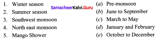
Answers:
1. (d)
2. (c)
3. (b)
4. (e)
5. (a)
IV. Assertion type Question.
Question 1.
Assertion (A): Tamil Nadu does not receive much rainfall from the southwest monsoon. Reasoning (R): It is situated in the rain shadow area of the Western Ghats.
(a) Both (A) and (R) are true and (R) explains (A).
(b) Both (A) and (R) are true but, (R) does not explain (A).
(c) (A) is true but, (R) is false.
(d) (R) is true but, (A) is false.
Answer:
(a) Both (A) and (R) are true and (R) explains (A).
Question 2.
Assertion (A): Red soil is rich in iron oxides Reasoning (R): It is formed by leaching
(a) Both (A) and (R) are true and (R) explains (A).
(b) Both (A) and (R) are true but, (R) does not explain (A).
(c) (A) is true but, (R) is false.
(d) (R) is true but, (A) is false.
Answer:
(b) Both (A) and (R) are true but, (R) does not explain (A).
V. Answer the following questions briefly.
Question 1.
State the boundaries of Tamil Nadu.
Answer:
Tamil Nadu is bounded by Bay of Bengal in the East, Kerala in the West, Andhra Pradesh in the North Karnataka in the North West and Indian Ocean in the South.
Question 2.
List out the districts of Tamil Nadu which are partly/fully located on Eastern and Western Ghats separately.
Answer:
Eastern Ghats:
Parangimalai, Chennai, Javadhu hills, Vellore, Salem, Sirumalai, Dindigul, Thiruvannamalai, Bhubaneswar, Namakkal, Perambalur.
Western Ghats:
Kanyakumari, Tirunelveli, Theni, Coimbatore, Nilgiri.
Question 3.
What is ‘Teri’?
Answer:
The sand dunes formed along the coast of Ramanathapuram and Thoothukudi districts are called “Teri”.
Question 4.
How is coastal plain formed?
Answer:
It is formed by the rivers that flow towards east and drain in the Bay of Bengal.
Question 5.
Name the major islands of Tamil Nadu.
Answer:
Pamban, Hare, Kurusadai, Nallathanni Theevu, Pullivasal, Srirangam, Upputanni, Island grounds, Kattupalli Island, Quibble island and Vivekananda rock memorial are some major islands of Tamil Nadu.
Question 6.
Name the tributaries of river Thamirabarani.
Answer:
Karaiyar, Servalar, Manimuthar, Gadananathi, Pachaiyar, Chittar and Ramanathi are its main tributaries.
Question 7.
Define Disaster Risk Reduction.
Answer:
Disaster Risk Reduction (UNDRR) According to United Nations Office for Disaster Risk Reduction is “the concept and practice of reducing disaster risks through systematic efforts to analyses and reduce the causal factors of disasters”. This includes reducing exposure to hazards, lessening the vulnerability of people and property, wise management of land and environment and early warning for adverse events.
Question 8.
During cyclone, how does the Meterological department warn the fishermen?
Answer:
During disturbed weather over the seas, the ports likely to be affected are warned by concerned ACWCs / CWCs by advising the port authorities through port warnings to hoist appropriate Storm Warning Signals. The Department also issues “Fleet forecast” for Indian Navy. Coastal Bulletins for Indian coastal areas covering up to 75 km from the coastline and sea area bulletins for the sea areas beyond 75 km. The special warnings are issued for fishermen four times a day in normal weather and every three hourly in accordance with the four-stage warning in case of disturbed weather.
The general public, the coastal residents and fishermen are warned through state government officials and broadcast of warnings through All India Radio and National Television telecast programmes in national and regional hook up. A sytem of warning dissemination for fishermen through World Space Digital Based radio receiver is being planned.
VI. Distinguish between the following.
Question 1.
Western Ghats and Eastern Ghats.
Answer:
Western Ghats Eastern Ghats
| Western Ghats | Eastern Ghats |
| Western Ghats is a continuous one. Its average height is form 2,000 to 3000 m. | Eastern Ghats are not continuous and irregular. Its average height from is 1,100 to 1,600 metres |
| The Western Ghats enters the state through the Nilgiri District and runs upto KanyaKumari District | They extend from Northeast to Southwest through the districts of Vellore Dharmapuri and Erode |
| The highest hills of Western Ghats is Anaimalai (2700 m) | The highest hills of Eastern Ghats is Shervaryan hills (1500-1600 m) |
Question 2.
Southwest Monsoon and Northeast Monsoon.
Answer:
Southwest Monsoon Northeast Monsoon
Southwest Monsoon | Northeast Monsoon |
| Southwest Monsoon occurs between June to September. | North east monsoon occurs between Octobar and December. |
| It is Summer Monsoon. | It is Winter Monsoon. |
| The districts of Nilgiris, Kanyakumari, Salem, Coimbatore and Erode get rainfall. | The coromandal coast of Tamil Nadu gets heavy rainfall from north east monsoon. |
Question 3.
Tropical evergreen and Tropical deciduous forests.
Answer:
Tropical evergreen forest Tropical deciduous forests
Tropical evergreen forest | Tropical deciduous forests |
| They are called Evergreen forest since the leaves are present always | They are called Tropical Deciduous forests |
| They never shed their leaves | They shed their leaves to avoid loss of moisture during dry season |
| They are located in places which receive more than 200 cms of rainfall | They are located in areas which receive rainfall between 100 and 200 cms. |
VII. Give reasons for the following:
Question 1.
Eastern Ghats are not a continuous range.
Answer:
The Eastern Ghats are not a continuous range because it is dissected at many places by the rivers flowing towards the east that drain into the Bay of Bengal.
Question 2.
Tamil Nadu receives low rainfall during southwest monsoon.
Answer:
During southwest monsoon, Tamil Nadu is located in the rain shadow region for the wind, which blows from the Arabian sea. As a result, Tamil Nadu receives only a meagre rainfall from this monsoon. Rainfall during this season decreases from west to east.
Question 3.
Alluvial soil is fertile.
Answer:
Alluvial soil is formed by the deposition of rivers and are rich in minerals like lime, potassium magnesium, nitrogen and phosphoric acid. Hence it is fertile in nature.
Question 4.
Cuddalore is a multiprone disaster zone.
Answer:
Cuddalore districts is prone to natural calamities having experienced landfalls of major cyclones formed in the Bay of Bengal region. Apart from the cyclones, 2004 Tsunami caused massive damages to life and property in Cuddalore and its adjacent Nagapattinam district. Cyclone Thane which made landfall here caused major loss to life and property.
VIII. Answer the following in a paragraph.
Question 1.
Describe the nature of the plateau region of Tamil Nadu.
Answer:
- Location: Plateaus of Tamil Nadu are located between the Western Ghats and the Eastern Ghats.
- Area and Shape: It covers an area of about 60,000 sq. km and is roughly triangular in shape.
- Slope and height: It is broader in the North and very narrow in the South. It’s height increases from East to West ranging between 150 and 600 metres.
- Sub-divisions: Baramahal plateau, Coimbatore plateau and Madurai plateau.
Question 2.
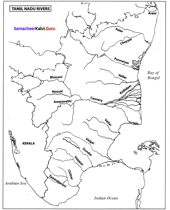
Write an account on river Cauvery.
Answer:
The main river of Tamil Nadu is cauvery which originates at Talacauvery in the Brahmragiri hills of Kodagu (coorg) district of Karnataka in the Western Ghats.
About 416 km of its course falls in Tamil Nadu. It serves as the boundary between Karnataka and Tamil Nadu for a distance of 64 km. A tributary called Bhavani joins Cauvery on the right bank about 45 km from the Mettur Reservoir.
Thereafter, it takes easterly course to enter into the plains of Tamil Nadu. Cauvery and its distributaries in its lower course drain the districts of Nagapattinam, Thanjavur, Thivarur and Thiruchirapalli. The cauvery, kollidam and the vellar jointly drain central part of the Tamil . Nadu. The head of the cauvery delta is near the islands of Srirangam. Kollidam branches off from cauvery at Grand Anaicut, also called as kallanai was built across the river cauvery.
After kallanai, the river breaks into a large number of distributaries and forms a network all over the delta. The network of tributaries within the delta of cauvery in the coast is called as the ‘Garden of Southern India’. It merges into Bay of Bengal to the south of cuddalore. Cauvery along with its tributaries Bhavani, Noyyal, Mayar and Amaravathi is the most important source of canal irrigation.
Question 3.
Explain the characteristic features of summer and winter seasons of Tamil Nadu.
Answer:
- The State of Tamil Nadu lies to the South of Tropic of cancer, which is near the Equator.
- As it receives vertical Sunrays, the temperature the State is relatively high throughout the year.
- But the climate of the coastal regions are influenced by the surrounding seas Bay of Bengal and the Indian Ocean enjoys tropical maritime climate.
Characteristic features of Summer Season:
- There is a steady rise in temperature from South to North.
- Generally the temperature various from 30°C to more than 40°C.
- Summer falls in the months of March, April and May. Hottest month is the month of May.
- In this season particularly in the month of May Southern , part of the. State receives some rainfall from pre-monsoon showers and some parts experience convectional rainfall.
Winter Season:
- During January and February Tamil Nadu receives the slanting rays of the sun.
- So the weather is slightly cooler. The difference between summer and winter temperature is not very high.
- Winter temperature in the State varies from 15°C to 25°C. However in hill stations it ranges from 5°C to 0°C forming thick mist and frost.
- The season is generally dry.
Question 4.
What is desertification and write about the areas affected by it in Tamil Nadu.
Answer:
Desertification is a type of land degradation in which a relatively dry areas of land becomes a desert, typically losing its bodies of water as well as vegetation and wild life. Theni, the Nilgiris and Kanniyakumari are the worst affected districts. About 12,000 hectares (120 Sq.km) were affected by sand deposition in Theni and Rajapalayam.
Question 5.
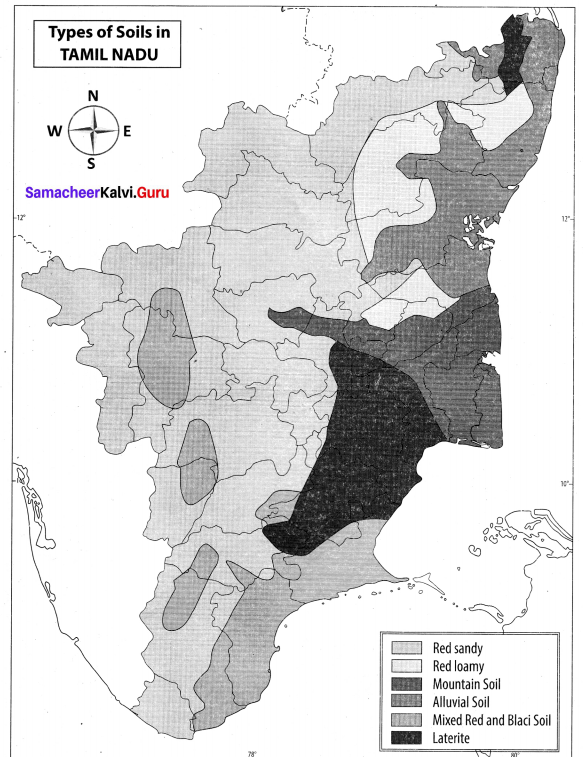
Bring out the types and distribution of soils in Tamil Nadu.
Answer:
| Types of Soils | Distribution of Soil in Tamil Nadu |
| Alluvial Soil | It is found in river valley regions and coastal plains. Thanjavur, Tiruvarur, Nagapattinam, Villupuram, Cuddalore, Tirunelveli and kanniyakumari |
| Black Soil | Coimbatore, Madurai, Virudhunagar, Tirunelveli and Thoothukudi |
| Red Soil | Sivagangai and Ramanathapuram |
| Laterite Soil | Kancheepuram, Tiruvallur and Thanjavur districts and source patches over the mountain region in the Nilgiris |
| Saline Soil | Saline soils in Tamil Nadu are confined to the Coromandel coast and vedaranyam |
Question 6.
Name the areas which are affected by landslides. What will you do before, during and after landslides?
Answer:
- A collapse of a mass of Earth or rock from a mountain or cliff is called landslide.
- One of the most vulnerable district affected by landslides is Nilgiris.
- The other regions which are prone to landslides are Coimbatore and Palani hill of Dindigul district.
Risk Reduction Measures:
Before:
- Create awareness
- Stay alert and awake
- Monitor the News update
- Make evacuation plan
- Listen for any unusual sounds indication such as.
- Moving debris – trees cracking, boulders knocking.
- Consider leaving the place of landslides if it is safe to do so.
During:
(a) If Indoors:
- Find cover in the section of the building that is farthest away from the approaching landslide.
- Take shelter under a strong table or bench.
- Hold on firmly and stay until all movement has ceased.
(b) If outdoors:
- Move quickly away from its likely path.
- Keeping clear of embankments, trees, power lines and poles.
- Avoid crossing roads and bridges and stay away from landslides.
- The slope may experience additional failures for hours todays afterwards.
(c) After:
- Stay away from the slide area.
- Listen to local radio or television for the latest emergency information.
- Watch for flooding which may occur after a landslide or debris flow.
- Check for injured and trapped persons near the slide, without entering the direct slide area.
IX. Map study
Question 1.
Mark important rivers, distribution of soil and forest types on different Tamil Nadu maps.
Answer:
In-text Activity
Question 1.
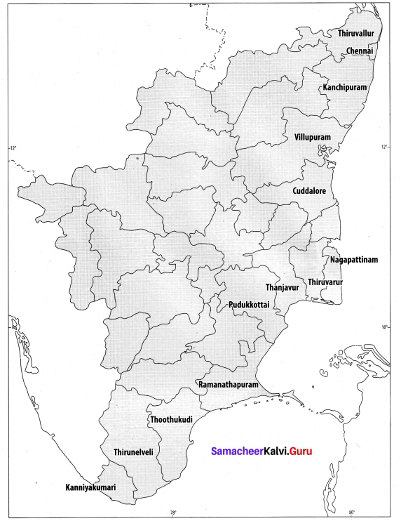
Find out the coastal districts of Tamil Nadu with the help of a map.
Answer:
Question 2.
Group the districts of Tamil Nadu which share their boundary with the states of Andhra Pradesh, Karnataka and Kerala separately.
Answer:
S. No | States | Districts of Tamil Nadu which share their boundary with other states |
| 1. | Andhra Pradesh | Vellore, Tiruvallur |
| 2. | Karnataka | Krishnagiri, Erode |
| 3. | Kerala | Nilgiris, Coimbatore, Teni, Tirunelveli, Kanyakumari |
In-Text Find Out
Question 1.
Name the first state of India created on linguistic basis.
Answer:
Andhra State on October 1st, 1953.
Question 2.
Why was the capital of Tamil Nadu renamed?
Answer:
The then local people called the capital of Tamil Nadu as Chennapattinam after the Vassal Chennapa Naicker who ruled this region and in the Sale Deed it was mentioned in the name after the Chenna Kesava temple which was the face of the city during that time. In 1996 Madras was officially renamed as Chennai in Tamil.
Question 3.
What is the meaning of the word ‘Chennai’?
Answer:
According to a suggestion, the city was named after the Chennakesava Perumal temple in the 1600s. The word Chennai in Tamil means ‘face’, with the temple regarded as the face of the city. The city was called Chennapatnam, which became to be abbreviated as Chennai.
Question 4.
Between in which latitude and longitude, is your school located?
Answer:
Do it yourself.
Question 5.
Why are mountain heights measured from mean sea level and not from ground level?
Answer:
Sea level is the base level for measuring elevation and depth on Earth. Because the ocean is one continuous body of water, its surface tends to seek the same level throughout the world.
Question 6.
Name the hill resorts of Western Ghats and Eastern Ghats in Tamil Nadu?
Answer:
Western Ghats: Annaimalai, Cardamon Hills, Palani Hills.
Eastern Ghats: Shevaroy Hills, Kalrayan Hills.
Question 7.
Is Ooty located on Western Ghats?
Answer:
Ooty is located on the Nilgiri hills which is a range of the Western Ghats.
Question 8.
Name the hill station located in Western Ghats and Eastern Ghats of Tamil Nadu?
Answer:
Western Ghats: Nilgiris, Kodaikanal, Annaimalai, Palani, Andipati and Agasthiyar Hills.
Eastern Ghats: Javadhu, Servarayan, Kalrayan, Kollimalai, Pachaimalai.
Question 9.
Why is the Nilgiri hills called as Blue Mountains?
Answer:
From all the directions and point of view these hills appear bluish hue in their natural settings. Hence the Nilgiri hills are called as Blue Mountains.
Question 10.
What is the kind of landform on which you live and what is its height?
Answer:
Do it yourself.
Question 11.
What is Agni Nakshatram?
Answer:
- Temperature of the states increases in the second week of February.
- Gradually it increases in the months of March, May and June.
- The hottest part of the summer season is known as “Agni Nakshatram” or Katthiriveyyil.
Question 12.
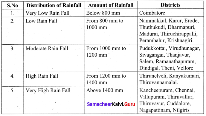
Group the districts of Tamil Nadu into low, moderate and heavy rainfall regions.
Answer:
S. No | Distribution of Rainfall | Regions |
| 1. | Low Rainfall | Nammakkal, karur, Erode, Thuthukudi, Dharmapuri, Madurai, Thiruchirappalli, perambalur, Krishnagiri. |
| 2. | Moderate Rainfall | Puddukottai, Virudhunagar, Sivagangai, Thanjavur, Salem, Ramanathapuram, Dindigal, Theni, Vellore. |
| 3. | Heavy Rainfall | Kancheepuram, chennai, Villupuram, Thiruvallur, Thiruvarur, Cuddalore, Nagapattinam, Nilgiri. |
Physical Geography of Tamil Nadu Additional Questions
I. Choose the correct answer.
Question 1.
There are ……………… districts in Tamil Nadu.
(a) 32
(b) 35
(c) 30
Answer:
(b) 35
Question 2.
Tamil Nadu is the ………………. largest State in India regarding its area.
(a) 10th
(b) 12th
(c) 11th
(d) 20th
Answer:
(c) 11th
Question 3.
The state lying on the …………… tip of the Indian Peninsula is Tamil Nadu.
(a) Southern
(b) Western
(c) Eastern
Answer:
(a) Southern
Question 4.
At present there are districts in Tamil Nadu.
(a) 25
(b) 35
(c) 14
(d) 29
Answer:
(b) 35
Question 5.
Geographically Tamil Nadu is divided into five ……………..
(a) Plain region
(b) Hilly region
(c) Physical division
Answer:
(c) Physical division
Question 6.
The topography of the Tamil Nadu State slopes towards:
(a) East
(b) West
(c) North
(d) South
Answer:
(a) East
Question 7.
………….. is located in the border of Tamil Nadu and Kerala.
(a) Nilgiri Hills
(b) Anaimalai
(c) Cardamom Hills
Answer:
(b) Anaimalai
Question 8.
Cardamom hills are also known as :
(a) Pachaimalai
(b) Servarayan
(c) Yelamalai
(d) Kalvarayan
Answer:
(c) Yelamalai
Question 9.
The trees of ……………. forest shed their leaves during dry season.
(a) Tidel
(b) Deciduous
(c) Evergreen
Answer:
(b) Deciduous
Question 10.
Kolli hills is a small mountain range located in district.
(a) Madurai
(b) Dindigal
(c) Namakkal
(d) Salem
Answer:
(c) Namakkal
Question 11.
…………… determines thickness of soil profile.
(a) Climate
(b) Time
(c) Wind
Answer:
(b) Time
Question 12.
The rivers of Tamil Nadu originates from :
(a) Eastern Ghats
(b) Western Ghats
(c) River plains
(d) Plateaus
Answer:
(b) Western Ghats
Question 13.
………….. is the most common trigger of a landslide.
(a) Air
(b) Fire
(c) Water
Answer:
(c) Water
Question 14.
………………. is also known as retreating monsoon.
(a) South west monsoon
(b) Tropical cyclones
(c) North east monsoon
(d) Pre-monsoon shower
Answer:
(c) North east monsoon
Question 15.
…………. dams are located at the foothills of Anaimalai.
(a) Aliyar and Tirumurthy
(b) Vaigai
(c) Mettur
Answer:
(a) Aliyar and Tirumurthy
II. Match the following.
a.
| 1. | State Bird | (a) | 226 |
| 2. | State Animal | (b) | Emerald Dove |
| 3. | State Tree | (c) | 234 |
| 4. | Assembly Constituencies | (d) | Palm tree |
| 5. | Taluks | (e) | Nilgiri Tahr |
Answer:
1. (b)
2. (e)
3. (d)
4. (c)
5. (a)
b.
| 1. | Tamil | (a) | South |
| 2. | 35 | (b) | Madurai |
| 3. | Indian Ocean | (c) | State Language |
| 4. | Vaigai | (d) | Queen of hills station |
| 5. | Ooty | (e) | Districts |
Answer:
1. (c)
2. (e)
3. (a)
4. (b)
5. (d)
III. Answer briefly:
Question 1.
Name the local bodies of Tamil Nadu:
Answer:
Tamil Nadu consists of:
- 35 – Districts
- 39 – Lok Sabha Constituencies
- 234 – Assembly Constituencies
- 76 – Revenue Division
- 125 – Municipalities
- 561 – Town Panchayats
- 12,618 – Village Panchayats
Question 2.
Name the passes that are found in the Western Ghats.
Answer:
The passes in the Western Ghats are Palghat, Shencottah, Aralvoimozhi and Achankoil.
Question 3.
Name the water bodies bordering Tamil Nadu.
Answer:
- Bay of Bengal on the east.
- Indian Ocean on the south.
Question 4.
Write a short note on Anaimalai.
Answer:
Anaimalai is located in the border of Tamil Nadu and Kerala. It is located in the South of Palghat gap. Valparai hill station and Kadamparai hydroelectric Power Plant are located on this hill. Anaimalai Tiger Reserve and Aliyar Reserve Forest is here. The dams Aliyar and Tirumurthy are located at the foothills of this range.
Question 5.
What are called Cholamandalam Plains?
Answer:
The coastal plains of Tiruvallur, Kanchipuram, Cuddalore and Villupuram are together known as the Cholamandalam Plains.
Question 6.
Name the districts that one located in the plains of Cauvery.
Answer:
The fertile plains of Cauvery is found in Salem, Erode, Karur, Tiruchirappalli, Pudukottai, Thanjavur, Thiruvarur and Nagapattinam.
Question 7.
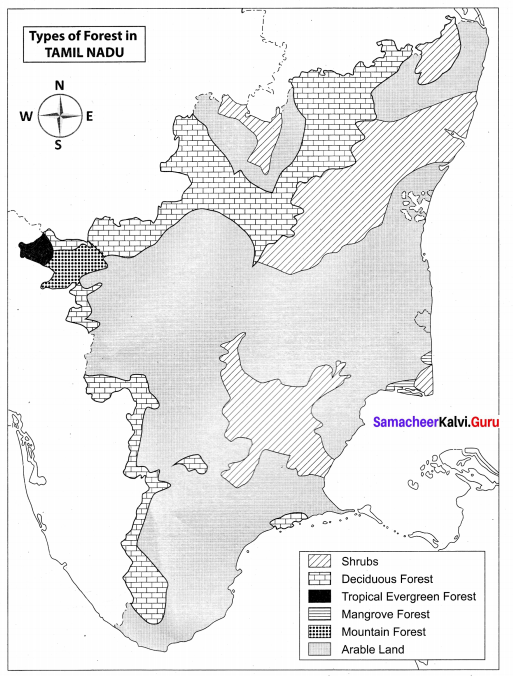
Name the types of forests found in Tamil Nadu.
Answer:
- Tropical Evergreen Forests
- Montane Temperate Forests
- Tropical Deciduous Forests
- Mangrove Forests and
- Tropical Thom Forests
Question 8.
Name the Wettest place in Tamil Nadu.
Answer:
Chinnakallar near Valparai is the Wettest place in Tamil Nadu. It is the third Wettest place in India.
Question 9.
What are the factors that determine the formation of soil?
Answer:
- Parent Rock
- Climate
- Relief
- Time factor
- Flora, fauna and micro organisms
Question 10.
Name of factors that are responsible for soil erosion.
Answer:
Soil erosion occurs due to deforestation, overgrazing, urbanisation and heavy rainfall.
IV. Distinguish Between:
Question 1.
Marina Beach and Rameshwaram Beach
Answer:
Marina Beach | Rameshwaram Beach |
| It is located in the city of Chennai. | It is located near the Gulf of Mannar. |
| It is one of the major tourist attraction of the city. | Pilgirms and tourists come here. |
| It extends to a distance of 13 kms. | The sea waves rise to a maximum height of 3 cm only. |
Question 2.
River Cauvery and River Vaigai
Answer:
River Cauvery | River Vaigai |
| It originates at Tala Cauvery in the Brahmagiri hills of Kodagu districts of Karnataka in the Western Ghats. | It rises from the eastern slopes of the Vamsanadu hills of Western Ghats of Tamil Nadu. |
| The main tributaries are Bhavani, Noyyal, Moyar and Amaravathi. | Its tributaries are Suruliyaur, Tayalaru and Mullaru. |
| Mettur dam has been constructed across Cauvery | Vaigai dam has been constructed across Vagai. |
Question 3.
Thorn forests and Mangrove forests
Answer:
Thorn forests | Mangrove forests |
| These forest are found in dry areas with low rainfall. | They are found in the tropical and subtropical tidal areas with high degree of salinity. |
| The vegetation is widely scattered to trees and bushes. | Mangrove trees grow along the estuaries and back waters. |
| They are highly adaptive to dry conditions with deep roots, thick items and fleshy leaves. | The trees belong to the genus Rhizophora. |
| They are found in the districts of Dharmapuri, Ramanathapuram, Viruthunagar districts in Tamil Nadu. | Pichavaram, Vedaranyam, Muthupet, Chatram and Thoothukudi in Tamil Nadu. |
V. Give Reasons:
Question 1.
Does Thanjavur has less than 1% of forest cover?
Answer:
- Thanjavur has alluvial soil
- It is suitable for agriculture
- So there is less then 1% of forest cover.
Question 2.
Why do Nilgiris and Kanyakumari get more rainfall during the southwest Monsoon season?
Answer:
- The south west monsoon occurs between June and September.
- Nilgiris, Kanyakumari, the western part of Coimbatore, Dharmapuri and Salem get benefitted during southwest monsoon season.
- As the southwest monsoon starts its downpour of rain in the western ghats, the western parts of Tamil Nadu receive about 150 cm of rain fall, on an average.
Question 3.
East Coast of Tamil Nadu does not receive much rainfall during Southwest Monsoon
Answer:
- This occurs due to the southwesterly direction of Monsoon winds.
- Most of the eastern and central parts of Tamil Nadu become rain shadow regions for this season.
VI. Answer in a paragraph.
Question 1.
Describe the geographical location of TamilNadu.
Answer:
- Tamil Nadu, a state in Southern India, is bordered by the states of Kerala, Karnataka and Andra pradesh.
- Bay of Bengal on the east, Indian ocean on the South, Kerala and Karnataka on the West and Andra Pradesh on the North.
- Gulf of Mannar and Palk strait separate Tamil Nadu from the Island of Srilanka, which lies to the South east of India.
- It is the 11th largest state in India.
- The state extends from 8° 4’N to 13° 35’N latitudes and from 76° 18’Eto 80° 20’E longitudes.
- Its Eastern and Western extremities are defined by the point Calimere and the hills of Anaimalai respectively.
- The Northern extremity of the state is marked by Pulicat lake and the Southern most point is Cape Comorin.
- The state of Tamil Nadu is a triangular land mass at the south eastern end of the continent.
- It has 1,076 km long coast line, the second longest in India.
Question 2.
Write about the rainfall regions of Tamil Nadu.
Answer:
Rainfall regions of Tamil Nadu Distribution of rain fall.
Question 3.
Write a paragraph on the Nilgiris hills.
Answer:
- The Nilgiri hills is located in the Northwestern part of Tamil Nadu.
- It consists of 24 peaks with more than 2000 metres height.
- Doddabetta is the highest peak (2,637 metres) followed by Mukkuruthi (2,554 metres).
- Ooty and Coonoor are the major hill stations.
- It has more than 2,700 species of flowering plants.
- The state animal Nilgiri Tahr is found in this hill.
- By extensive tea plantations and cattle grazing destroyed and disturbed much of the Nilgiris montane grasslands and shrublands.
We hope the information prevailed in this article is helpful for all the students of Class 10. The Tamilnadu State Board Samacheer Kalvi Solutions for Class 10 Social Science Geography Chapter 6 Physical Geography of Tamil Nadue Questions and Answer pdf enhance your skills and score good marks in the exams. Stay tuned to get the latest information about the Samacheer Kalvi 10th Social Science Geography Solutions Chapter 6 Physical Geography of Tamil Nadue.